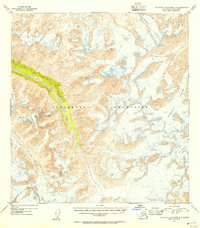
1954 Map of Talkeetna Mountains A-4
USGS Topo · Published 1954About this map
The Talkeetna Mountains dominate this high-altitude landscape in the mid-1950s, defined by a complex network of alpine glaciers and deep drainage basins. Flowing from the north, Sheep Creek carves a prominent valley through the center-west, while the massive Talkeetna Glacier and Chickaloon Glacier occupy the eastern portion of the quadrangle. The 1954 topography, derived from 1949 aerial photography, captures this wilderness before significant modern encroachment, showing the rugged contours and ice fields that feed tributaries like Iron Cr. The lack of named settlements or man-made infrastructure underscores the isolation of this region during the mid-century period, providing a precise record of glacial extents and natural drainage patterns that have likely shifted in the decades since.
Find a feature on this map
5 named features on this map. Tap any name to fly to it.
Don’t see what you’re looking for? This feature index may not catch every label — zoom into the map to look around manually.
Map Details
Editions of this 1954 Talkeetna Mountains A-4 Map
2 editions found
Other maps of this area

1948 · Anchorage D-4
USGS Topo · 1:63,360

1949 · Anchorage D-5
USGS Topo · 1:63,360

1949 · Talkeetna Mountains A-4
USGS Topo · 1:63,360

1950 · Talkeetna Mountains
USGS Topo · 1:250,000

1950 · Talkeetna Mountains B-5
USGS Topo · 1:63,360

1950 · Talkeetna Mountains B-4
USGS Topo · 1:63,360

1950 · Anchorage D-6
USGS Topo · 1:63,360

1950 · Talkeetna Mountains A-5
USGS Topo · 1:63,360

1951 · Anchorage
USGS Topo · 1:250,000

1951 · Talkeetna Mountains B-3
USGS Topo · 1:63,360