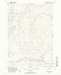
1951 Map of Anchorage D-8
USGS Topo · Published 1961About this map
The Kashwitna River and its southern tributaries define this 1951 landscape in the Susitna Valley, recorded just before the era of major highway expansion. The map illustrates a complex network of waterways, including Little Willow Creek and Willow Creek, which dominate the central and southern portions of the sheet. In this early post-war period, the area remained largely undeveloped, with limited human imprints such as a Sled Road in the southeast and an isolated Cabin near Purches Creek. Survey markers like VABM 3168 Willow and VABM 2450 Kash mark the higher elevations to the east. The dominance of river labels over settlement names suggests a wilderness in transition, where travel was still largely dictated by the natural drainage patterns of the Peters Creek and Deception Creek systems.
Find a feature on this map
15 named features on this map. Tap any name to fly to it.
Don’t see what you’re looking for? This feature index may not catch every label — zoom into the map to look around manually.
Map Details
Editions of this 1951 Anchorage D-8 Map
2 editions found

Other maps of this area

1949 · Tyonek
USGS Topo · 1:250,000

1949 · Anchorage D-7
USGS Topo · 1:63,360

1949 · Anchorage D-8
USGS Topo · 1:63,360

1950 · Talkeetna Mountains
USGS Topo · 1:250,000

1950 · Talkeetna
USGS Topo · 1:250,000

1950 · Anchorage C-8
USGS Topo · 1:63,360

1950 · Anchorage C-7
USGS Topo · 1:63,360

1950 · Talkeetna Mountains A-6
USGS Topo · 1:63,360

1951 · Talkeetna
USGS Topo · 1:250,000

1951 · Anchorage
USGS Topo · 1:250,000