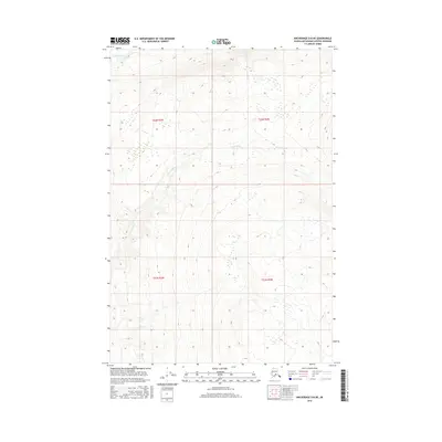
2016 Map of Anchorage D-8 NE
USGS Topo · Published 2016About this map
Kashwitna River defines the northern edge of this Matanuska-Susitna landscape, where the braided channels of glacial waters meet the lower slopes of the Talkeetna Mountains. The topography is dominated by the drainage system of Little Willow Cr, which winds through the central and southern portions of the territory. This map records the transition from the high, steep-contoured ridges to the more gradual wetlands that characterize the valley floor. The survey highlights the vast, unpopulated terrain of south-central Alaska before the major impacts of modern development, focusing on the natural hydrology and the Public Land Survey System boundaries that divide the wilderness into townships such as t22n r3w and t21n r2w.
Find a feature on this map
6 named features on this map. Tap any name to fly to it.
Don’t see what you’re looking for? This feature index may not catch every label — zoom into the map to look around manually.
Map Details
Editions of this 2016 Anchorage D-8 NE Map
This is the sole edition of this map. No revisions or reprints were ever made.
Other maps of this area

1949 · Anchorage D-7
USGS Topo · 1:63,360

1949 · Anchorage D-8
USGS Topo · 1:63,360

1950 · Talkeetna Mountains
USGS Topo · 1:250,000

1950 · Talkeetna Mountains A-6
USGS Topo · 1:63,360

1951 · Anchorage
USGS Topo · 1:250,000

1951 · Anchorage D-8
USGS Topo · 1:63,360

1951 · Anchorage D-7
USGS Topo · 1:63,360

1952 · Anchorage D-7
USGS Topo · 1:63,360

1952 · Anchorage D-8
USGS Topo · 1:63,360
1952 · Talkeetna Mountains A-6
USGS Topo · 1:63,360