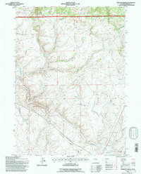
1991 Map of Anderson Ridge
USGS Topo · Published 1997About this map
The Continental Divide Wind River Range traverses this high-altitude landscape, marking the hydrological spine where waters separate toward the Pacific and Atlantic basins. Surveyed in 1991, the map details the convergence of the Bridger National Forest and Shoshone National Forest, a region defined by alpine drainages and complex topography. The Sweetwater River and its East Fork flow through the southern sections, while the northern slopes feed into Pine Creek and Jack Creek. Human presence is minimal and functional, represented by the Pinedale Rd, a remote Rest Area, and the isolated Shelter House near Fog Gulch. This map is particularly useful for understanding the historic transit corridors and water sources like Monument Spring and Sharps Meadows Springs that sustained travelers moving across Anderson Ridge.
Find a feature on this map
33 named features on this map. Tap any name to fly to it.
Don’t see what you’re looking for? This feature index may not catch every label — zoom into the map to look around manually.
Map Details
Editions of this 1991 Anderson Ridge Map
This is the sole edition of this map. No revisions or reprints were ever made.
Other maps of this area

1953 · Louis Lake
USGS Topo · 1:24,000

1953 · South Pass City
USGS Topo · 1:24,000

1953 · Christina Lake
USGS Topo · 1:24,000

1955 · Lander
USGS Topo · 1:250,000

1958 · Lander
USGS Topo · 1:250,000

1958 · Parting of the Ways
USGS Topo · 1:62,500

1958 · Hay Meadow Reservoir
USGS Topo · 1:24,000

1958 · Pacific Springs
USGS Topo · 1:24,000

1958 · Dickie Springs
USGS Topo · 1:24,000

1961 · Lander
USGS Topo · 1:250,000