
1922 Map of Andes
USGS Topo · Published 1955About this map
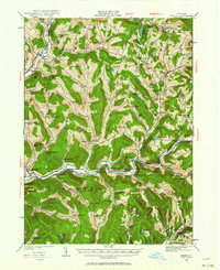
The East Branch Delaware River flows through the heart of this landscape, anchoring a valley where the lost hamlets of Pepacton, Shavertown, and Union Grove once thrived. This 1922 survey documents these communities before they were submerged by reservoir construction, detailing the intricate network of country schools that served the mountainsides, such as Tiffany Hollow School and Lower Dingle Hill School. The valley floors and hollows are dense with local history, from the New York Ontario and Western River rail corridor passing through Hamden and Delancey to the scattered farms connected by Farmers Hill Road. High ridges like Campbell Mountain and Perch Lake Mtn define the drainage basins of the Beaver Kill and Tremper Kill, revealing a 1920s topography where remote mountain gaps like Devils Backbone were still vital markers of the Catskill terrain.
Find a feature on this map
124 named features on this map. Tap any name to fly to it.
Don’t see what you’re looking for? This feature index may not catch every label — zoom into the map to look around manually.
Map Details
Editions of this 1922 Andes Map
2 editions found
Other maps of this area

1901 · Margaretville
USGS Topo · 1:62,500

1904 · Hobart
USGS Topo · 1:62,500

1904 · Margaretville
USGS Topo · 1:62,500

1909 · Delhi
USGS Topo · 1:62,500

1910 · Neversink
USGS Topo · 1:62,500

1911 · Delhi
USGS Topo · 1:62,500

1915 · Oneonta
USGS Topo · 1:62,500

1918 · Oneonta
USGS Topo · 1:62,500

1920 · Long Eddy
USGS Topo · 1:62,500

1921 · Long Eddy
USGS Topo · 1:48,000