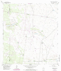
1956 Map of Andrea Ranch
USGS Topo · Published 1984About this map
Andrea Ranch sits at the heart of this South Texas landscape, where the border of Hidalgo and Kenedy counties cuts through a network of ranching infrastructure and hydrological features. The terrain is characterized by dunal formations like Los Cuyos de la Mula and a critical dependence on groundwater. The map documents an extensive array of water sources essential for livestock, including named sites such as the Buenos Aires Artesian Well, Finegan Artesian Well, and San Patricio Artesian Well.
Find a feature on this map
22 named features on this map. Tap any name to fly to it.
Don’t see what you’re looking for? This feature index may not catch every label — zoom into the map to look around manually.
Map Details
Editions of this 1956 Andrea Ranch Map
2 editions found
Other maps of this area

1922 · La Sal Vieja
USGS Topo · 1:62,500

1923 · Armstrong
USGS Topo · 1:62,500

1939 · Linn
USGS Topo · 1:62,500

1949 · Mc Allen
USGS Topo · 1:250,000

1953 · Brownsville
USGS Topo · 1:250,000

1954 · McAllen
USGS Topo · 1:250,000

1956 · Julian
USGS Topo · 1:24,000

1956 · Rudolph
USGS Topo · 1:24,000

1956 · Andrea Ranch
USGS Topo · 1:24,000

1956 · La Sal Vieja
USGS Topo · 1:24,000