
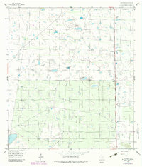
1956 Map of Rudolph
USGS Topo · Published 1957About this map
The coastal plains of South Texas in the mid-1950s appear here as a landscape defined by ranching infrastructure and the critical need for water management. The tiny settlement of Rudolph sits along the Missouri Pacific railroad, serving as a rare point of human habitation in a territory dominated by private ranch lands and fence lines. This era was characterized by the extensive use of artesian wells to support livestock in the arid brush country, visible in the distribution of sites like Mota Verde Artesian Well and Loma Prieta Artesian Well. The topography is subtle, featuring seasonal depressions such as La Badia del Divisadero and La Badia de Pitoso, alongside the low rise of Loma Prieta. This survey captures the reliance on rail transport and deep-well water sources that sustained the local cattle economy before more modern infrastructure transformed the Kenedy County interior.
Find a feature on this map
14 named features on this map. Tap any name to fly to it.
Don’t see what you’re looking for? This feature index may not catch every label — zoom into the map to look around manually.
Map Details
Editions of this 1956 Rudolph Map
2 editions found
Other maps of this area

1921 · Tarida Ranch
USGS Topo · 1:62,500

1922 · La Sal Vieja
USGS Topo · 1:62,500

1923 · Armstrong
USGS Topo · 1:62,500

1923 · Saltillo Ranch
USGS Topo · 1:62,500

1953 · Brownsville
USGS Topo · 1:250,000

1956 · Julian
USGS Topo · 1:24,000

1956 · Saltillo Well
USGS Topo · 1:24,000

1956 · Andrea Ranch
USGS Topo · 1:24,000

1956 · Rosita Lake
USGS Topo · 1:24,000

1956 · La Sal Vieja
USGS Topo · 1:24,000