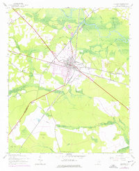
1943 Map of Andrews
USGS Topo · Published 1976About this map
Andrews sits at the junction of several rail corridors and local roads, serving as a hub between Williamsburg and Georgetown counties. This 1940s survey, updated with 1970s photogrammetric revisions, reveals a landscape defined by extensive low-lying wetlands such as Horse Pen Swamp and Boggy Swamp, which dictate the patterns of settlement. Higher ground is occupied by community landmarks like Antioch Ch and the Mt Lebanon Cem near West Andrews. The commercial growth of the mid-20th century is evident in the presence of a Drive-in Theater and the Andrews Municipal Airport. Rural life is anchored by traditional locales such as Harper Crossroads and Antioch, while the Seaboard Coast Line tracks underscore the importance of the timber and agricultural transport network connecting the coastal interior to the rest of South Carolina.
Find a feature on this map
33 named features on this map. Tap any name to fly to it.
Don’t see what you’re looking for? This feature index may not catch every label — zoom into the map to look around manually.
Map Details
Editions of this 1943 Andrews Map
3 editions found
Other maps of this area

1942 · Cedar Creek
USGS Topo · 1:24,000

1943 · Olin
USGS Topo · 1:31,680

1943 · Trio
USGS Topo · 1:24,000

1943 · Kilsock Bay
USGS Topo · 1:24,000

1943 · Rhems
USGS Topo · 1:24,000

1943 · Andrews
USGS Topo · 1:24,000

1943 · Jamestown
USGS Topo · 1:24,000

1946 · Indiantown
USGS Topo · 1:62,500

1949 · Georgetown
USGS Topo · 1:250,000

1967 · Georgetown
USGS Topo · 1:250,000