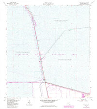
1963 Map of Andytown
USGS Topo · Published 1983About this map
Andytown sits at a critical junction in the Florida Everglades during the early 1960s, marking the intersection of the Everglades Parkway (Alligator Alley) and the North New River Canal. This 1963 survey, with later revisions, documents a landscape dominated by water management and conservation efforts, specifically within the Everglades Wildlife Management Area. The map reveals the intricate system of infrastructure required to manage the southern Florida wetlands, including numerous structures such as Control Gates, a Tollgate, and a Gaging Station.
Find a feature on this map
17 named features on this map. Tap any name to fly to it.
Don’t see what you’re looking for? This feature index may not catch every label — zoom into the map to look around manually.
Map Details
Editions of this 1963 Andytown Map
3 editions found
Other maps of this area

1956 · West Palm Beach
USGS Topo · 1:250,000

1957 · West Palm Beach
USGS Topo · 1:250,000

1958 · West Palm Beach
USGS Topo · 1:250,000

1963 · Andytown
USGS Topo · 1:24,000

1963 · Cooper City SW
USGS Topo · 1:24,000

1963 · Fort Lauderdale 2 SE
USGS Topo · 1:24,000
1963 · Cooper City NE
USGS Topo · 1:24,000
1963 · Cooper City
USGS Topo · 1:24,000

1973 · Everglades 4 NE
USGS Topo · 1:24,000

1973 · Everglades 4 SE
USGS Topo · 1:24,000