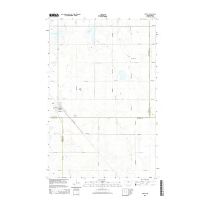
2014 Map of Aneta
USGS Topo · Published 2014About this map
Aneta serves as the primary hub of this eastern North Dakota landscape, where the intersection of ND-32 and ND-15 meets a grid of rural section roads. The town's layout is clearly defined by streets like Moon Ave and Thayer Ave, situated just north of the Nelson and Griggs County line. The rail influence is evident with the Bn Rr diagonal route cutting through the prairie south of the town center. Genealogists and local historians will find several rural burial sites, including Silent Hill Cem and Sacred Heart Cem, which stand as landmarks in an area dominated by natural prairie hydrology. Significant water features such as Matson Slough and Hillesland Lake break up the agricultural terrain, indicating the glacial pothole character of the region.
Find a feature on this map
43 named features on this map. Tap any name to fly to it.
Don’t see what you’re looking for? This feature index may not catch every label — zoom into the map to look around manually.
Map Details
Editions of this 2014 Aneta Map
This is the sole edition of this map. No revisions or reprints were ever made.
Other maps of this area

1939 · Niagara
USGS Topo · 1:62,500

1942 · McVille
USGS Topo · 1:62,500

1952 · Grand Forks
USGS Topo · 1:250,000

1952 · New Rockford
USGS Topo · 1:250,000

1956 · New Rockford
USGS Topo · 1:250,000

1956 · Grand Forks
USGS Topo · 1:250,000

1963 · Niagara SW
USGS Topo · 1:24,000
1963 · McVille SE
USGS Topo · 1:24,000

1963 · Logan Center
USGS Topo · 1:24,000

1966 · Grand Forks
USGS Topo · 1:250,000