
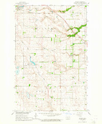
1963 Map of Logan Center
USGS Topo · Published 1965About this map
Glacial geology and rural township life converge at Logan Center, a quiet focal point in western Grand Forks County during the early 1960s. This survey, part of the Department of the Interior's development program for the Missouri River Basin, reveals a landscape dominated by the prominent Moraine terrain. The Little Goose River carves a winding path across the northern half of the sheet, providing a natural drainage system through the undulating prairie. The map captures essential local history landmarks for genealogists, including the Logan Center Cem and scattered rural homesteads. Resource extraction is evident through a designated Gravel Pit and smaller gravel workings in the eastern sections, while the township boundaries of Loretta and Logan Center define the administrative character of the agricultural plains.
Find a feature on this map
14 named features on this map. Tap any name to fly to it.
Don’t see what you’re looking for? This feature index may not catch every label — zoom into the map to look around manually.
Map Details
Editions of this 1963 Logan Center Map
This is the sole edition of this map. No revisions or reprints were ever made.
Other maps of this area

1936 · Larimore
USGS Topo · 1:62,500

1939 · Niagara
USGS Topo · 1:62,500

1952 · Grand Forks
USGS Topo · 1:250,000

1956 · Grand Forks
USGS Topo · 1:250,000

1963 · Niagara SW
USGS Topo · 1:24,000

1963 · Larimore SW
USGS Topo · 1:24,000

1963 · Larimore West
USGS Topo · 1:24,000
1963 · Niagara
USGS Topo · 1:24,000

1966 · Grand Forks
USGS Topo · 1:250,000

1967 · Finley NE
USGS Topo · 1:24,000