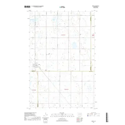
2017 Map of Aneta
USGS Topo · Published 2017About this map
Aneta serves as the primary hub of this eastern North Dakota prairie landscape, situated at the intersection of Co Hwy 7 and local routes like Moon Ave and Searns Ave. The surrounding terrain is defined by the unique wetland geography of the Drift Prairie, where numerous depressions form seasonal and permanent water bodies such as Solberg Slough, Matson Slough, and Pickerel Lake. This region sits at a significant political junction where the borders of Nelson, Grand Forks, Griggs, and Steele counties converge. For those researching family history, several dedicated burial grounds are preserved across the sections, including Sundahl Cem, Silent Hill Cem, and Sacred Heart Cem, reflecting the early settlement patterns and community centers that once thrived in this agricultural interior.
Find a feature on this map
29 named features on this map. Tap any name to fly to it.
Don’t see what you’re looking for? This feature index may not catch every label — zoom into the map to look around manually.
Map Details
Editions of this 2017 Aneta Map
This is the sole edition of this map. No revisions or reprints were ever made.
Other maps of this area

1939 · Niagara
USGS Topo · 1:62,500

1942 · McVille
USGS Topo · 1:62,500

1952 · Grand Forks
USGS Topo · 1:250,000

1952 · New Rockford
USGS Topo · 1:250,000

1956 · New Rockford
USGS Topo · 1:250,000

1956 · Grand Forks
USGS Topo · 1:250,000

1963 · Niagara SW
USGS Topo · 1:24,000
1963 · McVille SE
USGS Topo · 1:24,000

1963 · Logan Center
USGS Topo · 1:24,000

1966 · Grand Forks
USGS Topo · 1:250,000