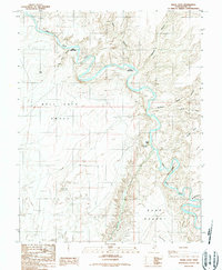
1986 Map of Angel Cove
USGS Topo · Published 1987About this map
The Dirty Devil River carves a deep, winding path through this corner of Wayne County, Utah, defining a landscape of high plateaus and abrupt descents. This 1980s-era provisional survey, based on decades of field data, reveals the geographic isolation of the Burr Desert and the sweeping expanse of the Hell Hole Swale. The topography is marked by significant erosion features, from the Upper Sand Slide and Lower Sand Slide along the river banks to the steep walls of Robbers Roost Canyon. Named landmarks such as Guss Knoll and Angel Point serve as navigational markers in a region where water sources like Angel Cove Spring were essential for early travelers and cattlemen. The map traces the intricate drainage patterns of the Saw Tooth and No Mans Canyon, illustrating the complex geology of the Colorado Plateau.
Find a feature on this map
16 named features on this map. Tap any name to fly to it.
Don’t see what you’re looking for? This feature index may not catch every label — zoom into the map to look around manually.
Map Details
Editions of this 1986 Angel Cove Map
2 editions found
Other maps of this area

1885 · San Rafael
USGS Topo · 1:250,000

1952 · Mt. Ellen 4 NW
USGS Topo · 1:24,000

1952 · Bull Mountain
USGS Topo · 1:62,500

1953 · Orange Cliffs 3 NW
USGS Topo · 1:24,000

1953 · Fiddler Butte
USGS Topo · 1:62,500

1954 · Mt. Ellen 1 NW
USGS Topo · 1:24,000

1954 · Mt. Ellen 1 SW
USGS Topo · 1:24,000

1956 · Salina
USGS Topo · 1:250,000

1960 · Salina
USGS Topo · 1:250,000

1962 · Salina
USGS Topo · 1:250,000