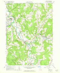
1964 Map of Angelica
USGS Topo · Published 1972About this map
The Genesee River carves a winding path through this mid-1960s survey of Allegany County, anchoring a landscape where agricultural plateaus meet steep wooded hills. The village of Angelica serves as a local hub, featuring the County Fairgrounds and Central Sch, while the Erie-Lackawanna Railroad traces the valley floor, connecting the settlements of Belfast, Oramel, and Belvidere.
Find a feature on this map
70 named features on this map. Tap any name to fly to it.
Don’t see what you’re looking for? This feature index may not catch every label — zoom into the map to look around manually.
Map Details
Editions of this 1964 Angelica Map
3 editions found
Other maps of this area

1906 · Angelica
USGS Topo · 1:62,500

1916 · Canaseraga
USGS Topo · 1:62,500

1925 · Belmont
USGS Topo · 1:62,500

1926 · Wellsville
USGS Topo · 1:62,500

1939 · Belmont
USGS Topo · 1:62,500

1940 · Canaseraga
USGS Topo · 1:62,500

1941 · Angelica
USGS Topo · 1:62,500

1950 · Elmira
USGS Topo · 1:250,000

1958 · Elmira
USGS Topo · 1:250,000

1960 · Buffalo
USGS Topo · 1:250,000