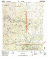
2004 Map of Angus
USGS Topo · Published 2006About this map
Lincoln National Forest and the White Mountain Wilderness dominate this high-elevation landscape, where the waters of Bonito Lake and the Rio Bonito form a vital alpine drainage system. The map reveals a transition from the protected peaks of Monjeau Peak and Buck Mountain to the growing residential footprints of Sun Valley, Alpine Village, and the northern reaches of Ruidoso. Near the center of the sheet, the Villa Madonna retreat and the Loma Grande Ranch represent the legacy of private landholdings within the surrounding public forest.
Find a feature on this map
47 named features on this map. Tap any name to fly to it.
Don’t see what you’re looking for? This feature index may not catch every label — zoom into the map to look around manually.
Map Details
Editions of this 2004 Angus Map
This is the sole edition of this map. No revisions or reprints were ever made.
Other maps of this area

1934 · Capitan
USGS Topo · 1:48,000

1937 · Capitan
USGS Topo · 1:62,500

1938 · Carrizozo
USGS Topo · 1:48,000

1943 · Carrizozo
USGS Topo · 1:62,500

1950 · Carrizozo
USGS Topo · 1:62,500

1950 · Sierra Blanca Peak
USGS Topo · 1:62,500

1955 · Roswell
USGS Topo · 1:250,000

1958 · Roswell
USGS Topo · 1:250,000

1962 · Roswell
USGS Topo · 1:250,000

1963 · Fort Stanton
USGS Topo · 1:24,000