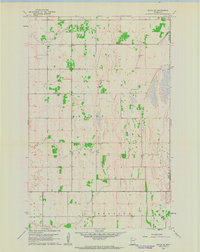
1961 Map of Angus SE
USGS Topo · Published 1963About this map
The agricultural grid of northwestern Minnesota is meticulously documented here, showing the rural structure of Helgeland, Brandt, and Belgium townships during the early 1960s. This survey, conducted by the Usgs using photogrammetric methods from 1954 and planetable surveys from 1961, preserves the locations of vital community centers in a region dominated by farm fields and section lines. Notable landmarks include the Melo Ch and an adjacent Cem, which served the local farming families of the area. Educational history is represented by School No 1659, while various Gravel Pit and Gravel Pits sites across the landscape indicate the local extraction of glacial deposits for road construction and infrastructure in this portion of Polk County.
Find a feature on this map
9 named features on this map. Tap any name to fly to it.
Don’t see what you’re looking for? This feature index may not catch every label — zoom into the map to look around manually.
Map Details
Editions of this 1961 Angus SE Map
This is the sole edition of this map. No revisions or reprints were ever made.
Other maps of this area

1918 · Angus
USGS Topo · 1:62,500

1918 · Red Lake Falls
USGS Topo · 1:62,500

1918 · Viking
USGS Topo · 1:62,500

1952 · Red Lake Falls
USGS Topo · 1:62,500

1952 · Grand Forks
USGS Topo · 1:250,000

1952 · Thief River Falls
USGS Topo · 1:250,000

1953 · Crookston
USGS Topo · 1:62,500

1956 · Thief River Falls
USGS Topo · 1:250,000

1956 · Grand Forks
USGS Topo · 1:250,000

1957 · Thief River Falls
USGS Topo · 1:250,000