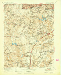
1951 Map of Annandale
USGS Topo · Published 1951About this map
Seven Corners and Baileys Crossroads anchor this 1951 snapshot of Fairfax County, capturing a landscape in the midst of a post-war transition from rural crossroads to suburban development. The emergence of the Shirley Memorial Highway and the Lee Boulevard transportation corridors is evident, yet the map still preserves dozens of smaller early-century residential subdivisions like Tremont Gardens, Devonshire Gardens, and Fairfax Hills. Strategic infrastructure defines the eastern edge, including the Falls Church Airport, the U S Army Depot, and the Coast Guard Radio Sta. Water management for the growing region is highlighted by the Alexandria Reservoir and Fort Belvoir Reservoir, while the legacy of the area's rural religious life remains visible at Sydenstricker Chapel and Clarks Chapel. The Southern railroad line still tracks through the southern portion of the quadrangle, serving local stops like Springfield Sta.
Find a feature on this map
115 named features on this map. Tap any name to fly to it.
Don’t see what you’re looking for? This feature index may not catch every label — zoom into the map to look around manually.
Map Details
Editions of this 1951 Annandale Map
2 editions found
Other maps of this area

1890 · Mt. Vernon
USGS Topo · 1:125,000

1891 · Mt. Vernon
USGS Topo · 1:125,000

1894 · Mt. Vernon
USGS Topo · 1:125,000

1897 · Mt. Vernon
USGS Topo · 1:125,000

1900 · Washington
USGS Topo · 1:62,500

1913 · Indian Head
USGS Topo · 1:62,500

1915 · Fairfax
USGS Topo · 1:62,500

1923 · Indian Head
USGS Topo · 1:48,000

1925 · Indian Head
USGS Topo · 1:62,500

1927 · Quantico
USGS Topo · 1:62,500