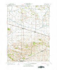
1929 Map of Annawan
USGS Topo · Published 1977About this map
The Chicago and Mississippi Canal cuts across the northern landscape, a critical waterway of late-19th and early-20th-century Illinois commerce. Paralleling the Chicago Rock Island and Pacific railroad, it defined the growth of Annawan and Mineral. This landscape is densely packed with one-room schoolhouses like Maple Grove Sch and Trading House Sch, highlighting a era of local, neighborhood-centered rural education before mid-century consolidation. Further south, the coal-rich terrain near Kewanee and Neponset shows the transition from heavy industry to the sprawling agricultural tracts of Cornwall and Neponset townships. The map records a grid of early auto routes, including State Highway No 7, connecting the hamlets of Bobtown and Brandenburg Corners to the larger rail hubs. Small community anchors like Fairview Ch and the recreational grounds of Francis Park provide a look at the social geography of Henry and Bureau counties during the late 1920s.
Find a feature on this map
76 named features on this map. Tap any name to fly to it.
Don’t see what you’re looking for? This feature index may not catch every label — zoom into the map to look around manually.
Map Details
Editions of this 1929 Annawan Map
2 editions found
Other maps of this area

1899 · Clinton
USGS Topo · 1:125,000

1921 · Buda
USGS Topo · 1:62,500

1923 · Buda
USGS Topo · 1:62,500

1929 · Annawan
USGS Topo · 1:62,500

1931 · Galva
USGS Topo · 1:48,000

1932 · Prophetstown
USGS Topo · 1:48,000

1932 · Annawan
USGS Topo · 1:62,500

1933 · Camp Grove
USGS Topo · 1:48,000

1934 · Geneseo
USGS Topo · 1:62,500

1936 · Prophetstown
USGS Topo · 1:62,500