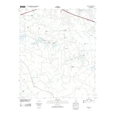
2010 Map of Annetta
USGS Topo · Published 2010About this map
Center Point and the series of small communities known as Annetta, Annetta North, and Annetta South anchor this portion of Parker County just south of the interstate corridor. The landscape is defined by the winding course of the Clear Fork Trinity River and a network of engineered water features, including Lake Moncrief, Meeker Lake, and Reservoir Number Thirtythree. The map illustrates a transitional suburban-rural character, where older landmarks like the Devils Backbone ridge and Joe Bell Mountain stand alongside the Parker County Airport and modern residential developments branching off Bear Creek Road. Genealogists will find several burial sites preserved among these hills, including Dixon Cemetery, Willow Springs Cemetery, and O'Neal Cemetery, providing a clear record of the area's established family roots.
Find a feature on this map
80 named features on this map. Tap any name to fly to it.
Don’t see what you’re looking for? This feature index may not catch every label — zoom into the map to look around manually.
Map Details
Editions of this 2010 Annetta Map
This is the sole edition of this map. No revisions or reprints were ever made.
Other maps of this area

1891 · Weatherford
USGS Topo · 1:125,000

1893 · Weatherford
USGS Topo · 1:125,000

1924 · Weatherford 3-d
USGS Topo · 1:48,000

1931 · Dennis
USGS Topo · 1:62,500

1932 · Springtown
USGS Topo · 1:62,500

1954 · Dallas
USGS Topo · 1:250,000

1955 · Aledo
USGS Topo · 1:24,000
1955 · Cresson
USGS Topo · 1:24,000
1955 · Springtown SE
USGS Topo · 1:24,000

1958 · Dallas
USGS Topo · 1:250,000