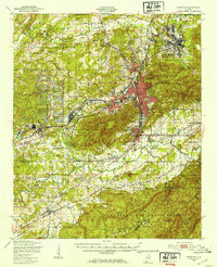
1950 Map of Anniston
USGS Topo · Published 1953About this map
Industrial and military installations define the landscape surrounding Anniston at the start of the 1950s. The massive Fort McClellan Military Reservation dominates the north, containing specialized zones like the Pelham Range and the now-labeled Reilly Airfield (Abandoned). To the west, the extensive grid of the Anniston Ordnance Depot occupies several square miles, illustrating the scale of local defense manufacturing and storage during this era.
Find a feature on this map
84 named features on this map. Tap any name to fly to it.
Don’t see what you’re looking for? This feature index may not catch every label — zoom into the map to look around manually.
Map Details
Editions of this 1950 Anniston Map
2 editions found

Other maps of this area

1889 · Springville
USGS Topo · 1:125,000

1890 · Talladega
USGS Topo · 1:125,000

1891 · Ashland
USGS Topo · 1:125,000

1892 · Springville
USGS Topo · 1:125,000

1892 · Talladega
USGS Topo · 1:125,000

1900 · Anniston
USGS Topo · 1:125,000

1943 · Talladega
USGS Topo · 1:62,500

1946 · Talladega
USGS Topo · 1:62,500

1947 · Oxford
USGS Topo · 1:24,000

1947 · Anniston
USGS Topo · 1:24,000