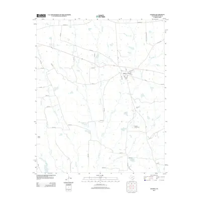
2012 Map of Annona
USGS Topo · Published 2012About this map
Annona serves as the central hub of this Red River County landscape, where the local street grid intersects with Main St and Old English Rd. The surrounding terrain is defined by a dense network of tributaries including Kickapoo Cr and White Oak Cr, which feed several smaller bodies of water like Bentsen Lake and Magic Valley Lake. To the west, the open expanse of Peters Prairie provides a distinct geographical contrast to the creek-carved lowlands. This survey illustrates a rural Texas economy transitioning into the 21st century, where large-scale ranching and aviation interests like Russells Ranch Airport sit alongside older local landmarks such as Garland Cem. The detailed road network, from Farm Road 114 to the numerous county roads, highlights the modern connectivity of this historically agricultural region.
Find a feature on this map
56 named features on this map. Tap any name to fly to it.
Don’t see what you’re looking for? This feature index may not catch every label — zoom into the map to look around manually.
Map Details
Editions of this 2012 Annona Map
This is the sole edition of this map. No revisions or reprints were ever made.
Other maps of this area

1950 · White Rock
USGS Topo · 1:24,000

1950 · Annona
USGS Topo · 1:24,000

1951 · English
USGS Topo · 1:24,000

1951 · Annona
USGS Topo · 1:24,000

1951 · White Rock
USGS Topo · 1:24,000

1951 · Avery
USGS Topo · 1:24,000

1953 · Texarkana
USGS Topo · 1:250,000

1956 · Texarkana
USGS Topo · 1:250,000

1964 · Cuthand
USGS Topo · 1:24,000
1964 · Dimple
USGS Topo · 1:24,000