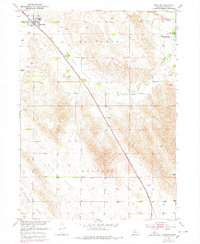
1951 Map of Anselmo
USGS Topo · Published 1978About this map
The Anselmo townsite and its surrounding Sandhills valleys are documented here at the mid-century point, illustrating the rural structure of Custer County. The Burlington Northern railroad cuts a diagonal line through the landscape, linking the small grid of Anselmo to the agricultural valleys of New Hope Valley and Dale Valley. The map reveals a community-focused geography defined by a network of rural schoolhouses and cemeteries, such as Maroney Sch, Keota Sch, and Dale Sch, which served the scattered farmsteads of Kilfoil and Ortello Valley. To the northeast, the transition from ranch land to recreation is evident at Victoria Springs State Park, located near the settlement of New Helena and the winding Victoria Creek. This survey provides a precise record of the schools and family burial grounds that anchored Nebraska's central prairie communities before many rural institutions were consolidated.
Find a feature on this map
23 named features on this map. Tap any name to fly to it.
Don’t see what you’re looking for? This feature index may not catch every label — zoom into the map to look around manually.
Map Details
Editions of this 1951 Anselmo Map
3 editions found
Other maps of this area

1951 · Lillian
USGS Topo · 1:24,000

1951 · Callaway NW
USGS Topo · 1:24,000

1951 · Anselmo
USGS Topo · 1:24,000

1951 · Broken Bow
USGS Topo · 1:24,000

1951 · Merna
USGS Topo · 1:24,000

1951 · Anselmo SW
USGS Topo · 1:24,000

1951 · Anselmo NE
USGS Topo · 1:24,000

1951 · Anselmo NW
USGS Topo · 1:24,000

1951 · Milburn
USGS Topo · 1:24,000

1955 · Broken Bow
USGS Topo · 1:250,000