
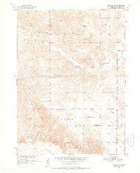
1951 Map of Anselmo SW
USGS Topo · Published 1952About this map
Ortello Chapel and the nearby Ortello Cem serve as the spiritual and social heart of this Custer County landscape during the early 1950s. The region is characterized by a sparse, rural infrastructure where life centered around small township districts like Victoria, Cliff, and Ortel. Education was highly localized, evidenced by the distribution of several one-room schoolhouses, including Delmont Sch, Phillips Sch, and Ortello Sch. The physical geography is defined by a transition from the rolling Sand Hayes Valley in the north to the higher plateau of West Table in the southwest. This map records the precise locations of these civic landmarks and family burial grounds before mid-century consolidation changed the footprint of rural Nebraska communities.
Find a feature on this map
12 named features on this map. Tap any name to fly to it.
Don’t see what you’re looking for? This feature index may not catch every label — zoom into the map to look around manually.
Map Details
Editions of this 1951 Anselmo SW Map
2 editions found
Other maps of this area

1948 · Linscott
USGS Topo · 1:62,500

1950 · Linscott
USGS Topo · 1:62,500

1951 · Callaway NW
USGS Topo · 1:24,000

1951 · Anselmo
USGS Topo · 1:24,000

1951 · Merna
USGS Topo · 1:24,000

1951 · Anselmo NE
USGS Topo · 1:24,000

1951 · Anselmo NW
USGS Topo · 1:24,000

1954 · North Platte
USGS Topo · 1:250,000

1955 · Broken Bow
USGS Topo · 1:250,000

1956 · Broken Bow
USGS Topo · 1:250,000