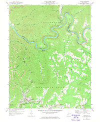
1969 Map of Ansted
USGS Topo · Published 1973About this map
The Gauley River carves a dramatic path through this central West Virginia landscape, punctuated by the sharp oxbow at Koontz Bend and the presence of the Penn Central and Chesapeake and Ohio railroads. The town of Ansted serves as a primary hub of settlement near Hawks Nest State Park, where the Gauley Mtn Lookout Tower stands atop the high ridges. The map reveals an industrial economy centered on natural resources, evidenced by numerous gas wells and strip mines dotting the terrain of Gauley Mountain.
Find a feature on this map
66 named features on this map. Tap any name to fly to it.
Don’t see what you’re looking for? This feature index may not catch every label — zoom into the map to look around manually.
Map Details
Editions of this 1969 Ansted Map
2 editions found
Other maps of this area

1889 · Nicholas
USGS Topo · 1:125,000

1891 · Nicholas
USGS Topo · 1:125,000

1897 · Kanawha Falls
USGS Topo · 1:125,000

1900 · Kanawha Falls
USGS Topo · 1:125,000

1901 · Nicholas
USGS Topo · 1:125,000

1901 · Kanawha Falls
USGS Topo · 1:125,000

1908 · Clay
USGS Topo · 1:48,000

1908 · Fayetteville
USGS Topo · 1:48,000

1910 · Clay
USGS Topo · 1:62,500

1910 · Fayetteville
USGS Topo · 1:62,500