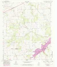
1962 Map of Antelope Creek NW
USGS Topo · Published 1982About this map
The Millers Creek Reservoir dominates the southeastern corner of this landscape at the intersection of Baylor, Throckmorton, and Haskell counties. Revisions from 1979 illustrate the reservoir's extent along the valleys of Millers Creek and Wolf Creek, providing a sharp contrast to the surrounding terrain marked by an extensive oil field and complex drainage systems. Several intermittent streams, including Mexican Creek, Lake Creek, and Rocky Creek, carve through the rolling country north of the water.
Find a feature on this map
15 named features on this map. Tap any name to fly to it.
Don’t see what you’re looking for? This feature index may not catch every label — zoom into the map to look around manually.
Map Details
Editions of this 1962 Antelope Creek NW Map
2 editions found
Other maps of this area

1954 · Wichita Falls
USGS Topo · 1:250,000

1958 · Wichita Falls
USGS Topo · 1:250,000

1962 · Antelope Creek SW
USGS Topo · 1:24,000

1962 · Antelope Creek SE
USGS Topo · 1:24,000

1962 · Antelope Creek NE
USGS Topo · 1:24,000

1962 · Antelope Creek NW
USGS Topo · 1:24,000

1966 · Seymour West
USGS Topo · 1:24,000

1966 · Bomarton
USGS Topo · 1:24,000

1967 · Hefner
USGS Topo · 1:24,000

1967 · Mattson
USGS Topo · 1:24,000