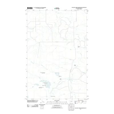
2011 Map of Antelope Creek Reservoir
USGS Topo · Published 2011About this map
The T and S Stock Company Number 5 Dam and its counterparts dominate the drainage patterns of this eastern Montana landscape, reflecting the intensive water management required for ranching in McCone County. These stock dams are scattered across a complex network of coulees, including Browns Coulee and O'Dell Coulee, where they capture seasonal runoff to support livestock. The largest of these impoundments, the Antelope Creek Reservoir, sits at the heart of the terrain, while others like the Ace of Spades Dam and Dealers Choice Dam hint at the local character of the ranching operations.
Find a feature on this map
22 named features on this map. Tap any name to fly to it.
Don’t see what you’re looking for? This feature index may not catch every label — zoom into the map to look around manually.
Map Details
Editions of this 2011 Antelope Creek Reservoir Map
This is the sole edition of this map. No revisions or reprints were ever made.
Other maps of this area

1915 · Oswego
USGS Topo · 1:62,500

1916 · Wolf Point
USGS Topo · 1:62,500

1954 · Glendive
USGS Topo · 1:250,000

1954 · Wolf Point
USGS Topo · 1:250,000

1957 · Glendive
USGS Topo · 1:250,000

1958 · Wolf Point
USGS Topo · 1:250,000

1958 · Glendive
USGS Topo · 1:250,000

1972 · Wolf Point
USGS Topo · 1:24,000

1972 · Macon
USGS Topo · 1:24,000
1972 · Flynn Creek South
USGS Topo · 1:24,000