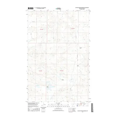
2017 Map of Antelope Creek Reservoir
USGS Topo · Published 2017About this map
Antelope Cr Reservoir and several neighboring catchments define the water management landscape of this McCone County territory. The terrain is characterized by a complex network of coulees and intermittent streams, where small-scale damming has created features like Browns Coulee Reservoir and Upper O'Dell Coulee Reservoir to capture runoff in a dry environment. The drainages of Sand Cr, Mud Cr, and Crow Cr carve through the land, illustrating the natural erosional patterns that have shaped this portion of the Montana plains. Rural transportation is facilitated by named tracks such as Mendenhall Rd and Sorley Rd, which provide access to the remote sections of townships T25N and T26N. The presence of Preacher Coulee and Fullers Coulee suggests a history of local land naming based on early settlers or geographical landmarks, essential for genealogists tracing local movements.
Find a feature on this map
23 named features on this map. Tap any name to fly to it.
Don’t see what you’re looking for? This feature index may not catch every label — zoom into the map to look around manually.
Map Details
Editions of this 2017 Antelope Creek Reservoir Map
This is the sole edition of this map. No revisions or reprints were ever made.
Other maps of this area

1915 · Oswego
USGS Topo · 1:62,500

1916 · Wolf Point
USGS Topo · 1:62,500

1954 · Glendive
USGS Topo · 1:250,000

1954 · Wolf Point
USGS Topo · 1:250,000

1957 · Glendive
USGS Topo · 1:250,000

1958 · Wolf Point
USGS Topo · 1:250,000

1958 · Glendive
USGS Topo · 1:250,000

1972 · Wolf Point
USGS Topo · 1:24,000

1972 · Macon
USGS Topo · 1:24,000
1972 · Flynn Creek South
USGS Topo · 1:24,000