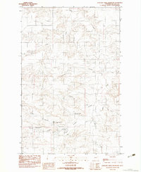
1983 Map of Antelope Creek Reservoir
USGS Topo · Published 1983About this map
Antelope Creek Reservoir sits at the center of this 1980s landscape in McCone County, Montana, where a complex network of coulees and seasonal drainages defines the local topography. This area is characterized by high-elevation prairie and breaklands, where small-scale water management is evident through multiple catchment features like the Upper O'Dell Coulee Reservoir and Browns Coulee Reservoir. These man-made features highlight the necessity of water storage for ranching and land use in this arid region.
Find a feature on this map
16 named features on this map. Tap any name to fly to it.
Don’t see what you’re looking for? This feature index may not catch every label — zoom into the map to look around manually.
Map Details
Editions of this 1983 Antelope Creek Reservoir Map
This is the sole edition of this map. No revisions or reprints were ever made.
Other maps of this area

1915 · Oswego
USGS Topo · 1:62,500

1916 · Wolf Point
USGS Topo · 1:62,500

1954 · Glendive
USGS Topo · 1:250,000

1954 · Wolf Point
USGS Topo · 1:250,000

1957 · Glendive
USGS Topo · 1:250,000

1958 · Wolf Point
USGS Topo · 1:250,000

1958 · Glendive
USGS Topo · 1:250,000

1972 · Wolf Point
USGS Topo · 1:24,000

1972 · Macon
USGS Topo · 1:24,000
1972 · Flynn Creek South
USGS Topo · 1:24,000