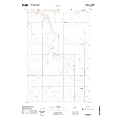
2020 Map of Antelope Flat
USGS Topo · Published 2020About this map
Antelope Flat and Leepers Flat dominate this portion of the Chouteau County landscape, defined by expansive upland plains cut by a network of drainage coulees. The local topography is carved by features like Alkali Coulee and Berry Coulee, which illustrate the seasonal water-shedding patterns of this high-plains region. Transportation and property access are managed by a grid of rural roads, many bearing names that hint at the area's agricultural and social history, including Sodbuster Rd and Davis School Rd. Near the eastern edge, Antelope Lake serves as a significant hydrologic focal point. The mapping also reveals a system of section lines and range identifiers such as t24n r4e, which provide the essential framework for land ownership and the township-and-range surveying system used throughout the West.
Find a feature on this map
25 named features on this map. Tap any name to fly to it.
Don’t see what you’re looking for? This feature index may not catch every label — zoom into the map to look around manually.
Map Details
Editions of this 2020 Antelope Flat Map
This is the sole edition of this map. No revisions or reprints were ever made.
Other maps of this area

1886 · Great Falls
USGS Topo · 1:250,000

1948 · Portage
USGS Topo · 1:62,500

1949 · Portage
USGS Topo · 1:62,500

1949 · Timber Coulee
USGS Topo · 1:62,500

1949 · Great Falls
USGS Topo · 1:62,500

1950 · Timber Coulee
USGS Topo · 1:62,500

1950 · Dent Bridge
USGS Topo · 1:62,500

1951 · Great Falls
USGS Topo · 1:62,500

1954 · Great Falls
USGS Topo · 1:250,000

1957 · Great Falls
USGS Topo · 1:250,000