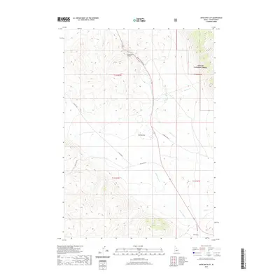
2020 Map of Antelope Flat
USGS Topo · Published 2020About this map
Antelope Flat defines the central topography of this Custer County landscape, situated at a crossroads of back-country routes within the Challis National Forest. The map documents a rugged drainage network where Warm Spring Cr and McGowan Cr carve through high-elevation terrain. A significant natural corridor is found at Grand View Canyon, which is followed by the Grand View Canyon Rd. Historically, this area is characterized by its seasonal water sources and remote ranching access, evidenced by landmarks like Summit Spring and the aptly named Broken Wagon Cr. To the south, Dry Gulch and Sheep Cr mark the descent toward the lower basins, while primitive tracks such as Spar Canyon Rd and S Lone Pine Rd provide the primary means of navigating this high-country expanse.
Find a feature on this map
19 named features on this map. Tap any name to fly to it.
Don’t see what you’re looking for? This feature index may not catch every label — zoom into the map to look around manually.
Map Details
Editions of this 2020 Antelope Flat Map
This is the sole edition of this map. No revisions or reprints were ever made.
Other maps of this area

1929 · Bayhorse
USGS Topo · 1:125,000

1935 · Borah Peak
USGS Topo · 1:125,000

1938 · Borah Peak
USGS Topo · 1:125,000

1955 · Dubois
USGS Topo · 1:250,000

1956 · Doublespring
USGS Topo · 1:62,500

1957 · Challis
USGS Topo · 1:250,000

1958 · Dubois
USGS Topo · 1:250,000

1960 · Challis
USGS Topo · 1:250,000

1963 · Challis
USGS Topo · 1:250,000
1963 · Little Antelope Flat
USGS Topo · 1:24,000