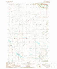
1987 Map of Antelope Lake
USGS Topo · Published 1987About this map
Antelope Lake sits at the heart of this high plains landscape in Chouteau County, surrounded by a complex network of seasonal drainage features characteristic of north-central Montana. The terrain is defined by deeply etched coulees, most notably Weatherwax Coulee and Antelope Coulee, which snake across the section lines toward the northern and southern boundaries. This 1987 provisional survey captures the area's agricultural and industrial infrastructure, including a prominent Transmission Line cutting across the southeastern corner. Along the northern edge, the Teton River flows through a valley marked by extensive Gravel deposits, indicating the fluvial processes that have shaped this prairie environment. The map provides a precise look at the township and range grid system, reflecting the organized land management of this wide-open ranching country.
Find a feature on this map
9 named features on this map. Tap any name to fly to it.
Don’t see what you’re looking for? This feature index may not catch every label — zoom into the map to look around manually.
Map Details
Editions of this 1987 Antelope Lake Map
This is the sole edition of this map. No revisions or reprints were ever made.
Other maps of this area

1886 · Great Falls
USGS Topo · 1:250,000

1890 · Fort Benton
USGS Topo · 1:250,000

1892 · Fort Benton
USGS Topo · 1:250,000

1897 · Fort Benton
USGS Topo · 1:250,000

1948 · Portage
USGS Topo · 1:62,500

1949 · Portage
USGS Topo · 1:62,500

1950 · Dent Bridge
USGS Topo · 1:62,500

1953 · Carter
USGS Topo · 1:24,000

1954 · Great Falls
USGS Topo · 1:250,000

1954 · Lander Crossing
USGS Topo · 1:24,000