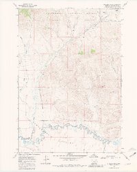
1968 Map of Antelope Peak
USGS Topo · Published 1981About this map
Antelope Peak stands as a prominent landmark in this high-altitude landscape within the Beaverhead National Forest of southwestern Montana. The terrain is defined by the dramatic slopes of the Snowcrest Range and the Long Divide, where numerous drainages like Fish Creek and Brundage Creek carve through the mountain facets. To the south, the topographic relief gives way to the broad Centennial Valley, dominated by the meandering course of the Red Rock River. The presence of the Lima Reservoir and the Gaging Sta along the river highlights the importance of water management in this arid ranching and forest region. Travelers and land managers in the late 1960s relied on the Centennial Divide Road to navigate this complex geography of timber and high-country pasture.
Find a feature on this map
24 named features on this map. Tap any name to fly to it.
Don’t see what you’re looking for? This feature index may not catch every label — zoom into the map to look around manually.
Map Details
Editions of this 1968 Antelope Peak Map
2 editions found

Other maps of this area

1950 · Lower Red Rock Lake
USGS Topo · 1:62,500

1950 · Monument Ridge
USGS Topo · 1:62,500

1955 · Dubois
USGS Topo · 1:250,000

1955 · Ashton
USGS Topo · 1:250,000

1958 · Dubois
USGS Topo · 1:250,000

1958 · Ashton
USGS Topo · 1:250,000

1960 · Ashton
USGS Topo · 1:250,000

1968 · Stonehouse Mountain
USGS Topo · 1:24,000

1968 · Corral Creek
USGS Topo · 1:24,000

1968 · Big Table Mountain
USGS Topo · 1:24,000