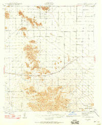
1946 Map of Antelope Peak
USGS Topo · Published 1958About this map
Antelope Peak stands as a prominent landmark in this 1946 survey of the arid borderlands between Maricopa and Pinal counties. The landscape is defined by the sharp elevations of the Table Top Mountains, including the high point at Table Top, and the expansive Hidden Valley to the north. This mid-century view documents the indigenous lands of the Maricopa Indian Reservation and the Papago Indian Reservation before significant modern development altered the drainage patterns of the desert floor. The intermittent flow of Vekol Wash dictates the placement of scattered water sources, indicated by various wells and tanks that supported ranching and transit through this desert corridor. The path of Route 84 provides the primary artery through the southern valley, connecting the isolated summits like Indian Butte and Papago Butte to the broader regional network.
Find a feature on this map
15 named features on this map. Tap any name to fly to it.
Don’t see what you’re looking for? This feature index may not catch every label — zoom into the map to look around manually.
Map Details
Editions of this 1946 Antelope Peak Map
3 editions found
Other maps of this area

1913 · Maricopa
USGS Topo · 1:62,500

1914 · Gila Butte
USGS Topo · 1:62,500

1915 · Maricopa
USGS Topo · 1:62,500

1917 · Gila Butte
USGS Topo · 1:62,500

1922 · Casa Grande
USGS Topo · 1:62,500

1924 · Casa Grande
USGS Topo · 1:62,500

1941 · Vekol Mountains
USGS Topo · 1:62,500

1942 · Silver Reef Mountains
USGS Topo · 1:62,500

1942 · Vekol Mountains
USGS Topo · 1:62,500

1946 · Antelope Peak
USGS Topo · 1:62,500