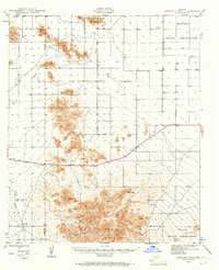
1946 Map of Antelope Peak
USGS Topo · Published 1961About this map
Antelope Peak and the high summits of the Table Top Mountains dominate this 1946 survey of the desert landscape south of Phoenix. The terrain is defined by dramatic outcrops and broad alluvial basins, including the expanse of Hidden Valley and the channel of Vekol Wash. The map documents a sparsely settled region divided by tribal and county boundaries, showing portions of the Maricopa Indian Reservation and Papago Indian Reservation meeting at the Maricopa Pinal Co line. While largely undeveloped, the presence of cattle tanks and wells like those near Lane indicate the ranching activity that sustained the local economy. Notable landmarks such as Table Top and Indian Butte served as essential navigational markers across this arid landscape before modern infrastructure transformed the area.
Find a feature on this map
15 named features on this map. Tap any name to fly to it.
Don’t see what you’re looking for? This feature index may not catch every label — zoom into the map to look around manually.
Map Details
Editions of this 1946 Antelope Peak Map
3 editions found
Other maps of this area

1913 · Maricopa
USGS Topo · 1:62,500

1914 · Gila Butte
USGS Topo · 1:62,500

1915 · Maricopa
USGS Topo · 1:62,500

1917 · Gila Butte
USGS Topo · 1:62,500

1922 · Casa Grande
USGS Topo · 1:62,500

1924 · Casa Grande
USGS Topo · 1:62,500

1941 · Vekol Mountains
USGS Topo · 1:62,500

1942 · Silver Reef Mountains
USGS Topo · 1:62,500

1942 · Vekol Mountains
USGS Topo · 1:62,500

1946 · Antelope Peak
USGS Topo · 1:62,500