
1949 Map of Antelope
USGS Topo · Published 1949About this map
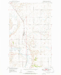
Antelope sits at the heart of this post-war survey, positioned along the Great Northern rail line in Sheridan County. The landscape is defined by the wandering path of Big Muddy Creek, which creates intricate oxbows and bends across the western half of the map. This area was documented as part of a Department of the Interior program focused on the development of the Missouri River Basin, reflecting a period of active land management and resource mapping.
Find a feature on this map
14 named features on this map. Tap any name to fly to it.
Don’t see what you’re looking for? This feature index may not catch every label — zoom into the map to look around manually.
Map Details
Editions of this 1949 Antelope Map
2 editions found
Other maps of this area

1948 · Reserve SE
USGS Topo · 1:24,000

1948 · Reserve
USGS Topo · 1:24,000

1948 · Alkali Coulee
USGS Topo · 1:24,000

1948 · Antelope
USGS Topo · 1:24,000

1949 · Reserve SE
USGS Topo · 1:24,000

1949 · Reserve
USGS Topo · 1:24,000

1949 · Alkali Coulee
USGS Topo · 1:24,000

1950 · Shippe Canyon
USGS Topo · 1:24,000

1954 · Wolf Point
USGS Topo · 1:250,000

1958 · Wolf Point
USGS Topo · 1:250,000