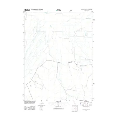
2012 Map of Antelope Valley
USGS Topo · Published 2012About this map
Antelope Valley defines this high-elevation Sierra Nevada landscape, where ranching and agricultural life are shaped by the surrounding topography of the Sierra Valley. The map captures a sophisticated network of named family roads and access lanes, including Genasci Rd, Filippini Rd, and Smith Ranch Rd, reflecting the generational landholdings of this California-Nevada border region. Water management is central to the area's utility, marked by the presence of Dyson Slough to the north and the Palen Reservoir tucked into the lower elevations.
Find a feature on this map
16 named features on this map. Tap any name to fly to it.
Don’t see what you’re looking for? This feature index may not catch every label — zoom into the map to look around manually.
Map Details
Editions of this 2012 Antelope Valley Map
This is the sole edition of this map. No revisions or reprints were ever made.
Other maps of this area

1890 · Sierraville
USGS Topo · 1:125,000

1892 · Sierraville
USGS Topo · 1:125,000

1894 · Sierraville
USGS Topo · 1:125,000

1950 · Chilcoot
USGS Topo · 1:62,500

1950 · Portola
USGS Topo · 1:62,500

1955 · Loyalton
USGS Topo · 1:62,500

1955 · Sierraville
USGS Topo · 1:62,500

1958 · Chico
USGS Topo · 1:250,000

1960 · Chico
USGS Topo · 1:250,000
1972 · Portola
USGS Topo · 1:24,000