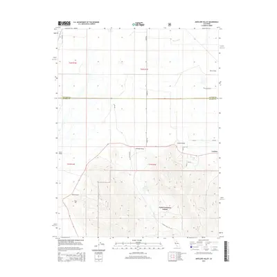
2015 Map of Antelope Valley
USGS Topo · Published 2015About this map
Loyalton sits at the edge of the expansive Sierra Valley, where the high desert floor meets the northern reaches of the Tahoe National Forest. This 2015 survey illustrates a landscape defined by the transition from ranching flats to timbered ridges, with the Plumas and Sierra county line bisecting the northern portion of the quadrangle. The topography reveals significant water management and land use patterns, from the Palen Reservoir tucked into the southern hills to the drainage of Dyson Slough in the north. A network of rural routes such as Filippini Rd and Bar One Ranch Rd connect scattered homesteads and livestock operations across Antelope Valley. Natural landmarks like Lombardi Point and Rice Hill provide geographic context for the complex terrain surrounding the canyon systems of the national forest.
Find a feature on this map
26 named features on this map. Tap any name to fly to it.
Don’t see what you’re looking for? This feature index may not catch every label — zoom into the map to look around manually.
Map Details
Editions of this 2015 Antelope Valley Map
This is the sole edition of this map. No revisions or reprints were ever made.
Other maps of this area

1890 · Sierraville
USGS Topo · 1:125,000

1892 · Sierraville
USGS Topo · 1:125,000

1894 · Sierraville
USGS Topo · 1:125,000

1950 · Chilcoot
USGS Topo · 1:62,500

1950 · Portola
USGS Topo · 1:62,500

1955 · Loyalton
USGS Topo · 1:62,500

1955 · Sierraville
USGS Topo · 1:62,500

1958 · Chico
USGS Topo · 1:250,000

1960 · Chico
USGS Topo · 1:250,000
1972 · Portola
USGS Topo · 1:24,000