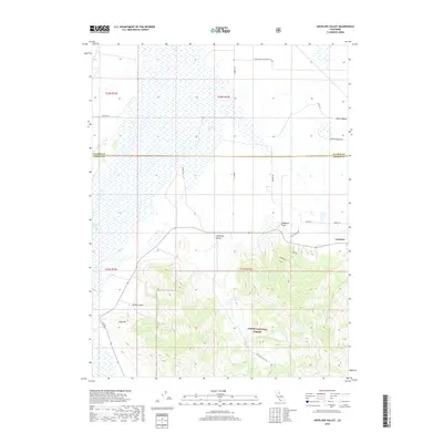
2018 Map of Antelope Valley
USGS Topo · Published 2018About this map
Loyalton sits at the edge of the high-altitude flatlands where the Sierra Valley meets the rising slopes of the Tahoe National Forest. This 2018 survey documents the interface between the agricultural valley floor and the timbered mountain terrain. In the northern section, the landscape is defined by large-scale ranching and drainage networks, evidenced by several family-named corridors such as Smith Ranch Rd and Bar One Ranch Rd. To the south, the topography shifts abruptly into the ridges and canyons of the forest, featuring landmarks like Lombardi Point and Mello Canyon. The transition from the open Antelope Valley to the forested hills around Rice Hill illustrates the classic land-use patterns of the Sierra Nevada's eastern edge, where irrigation features like Palen Reservoir support the valley's cattle and hay production.
Find a feature on this map
24 named features on this map. Tap any name to fly to it.
Don’t see what you’re looking for? This feature index may not catch every label — zoom into the map to look around manually.
Map Details
Editions of this 2018 Antelope Valley Map
This is the sole edition of this map. No revisions or reprints were ever made.
Other maps of this area

1890 · Sierraville
USGS Topo · 1:125,000

1892 · Sierraville
USGS Topo · 1:125,000

1894 · Sierraville
USGS Topo · 1:125,000

1950 · Chilcoot
USGS Topo · 1:62,500

1950 · Portola
USGS Topo · 1:62,500

1955 · Loyalton
USGS Topo · 1:62,500

1955 · Sierraville
USGS Topo · 1:62,500

1958 · Chico
USGS Topo · 1:250,000

1960 · Chico
USGS Topo · 1:250,000
1972 · Portola
USGS Topo · 1:24,000