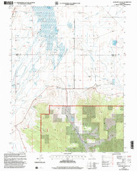
2000 Map of Antelope Valley
USGS Topo · Published 2003About this map
Sierra Valley Channels dominate the northern landscape of this survey, illustrating a complex hydrologic network where the valley floor transitions into the heights of the Tahoe National Forest. The map documents a rural environment defined by water management and ranching infrastructure, evidenced by numerous Flowing Wells and the Palen Reservoir. Distinctive landmarks such as Lombardi Point and Rice Hill provide topographical orientation above the Antelope Valley floor. A legacy of agricultural and civil engineering is visible in the alignment of the Westside Road and various Levee systems that navigate the marshy terrain of Dyson Slough. This revision by the USDA Forest Service reflects the land use patterns at the close of the twentieth century, balancing protected forest lands with the utilitarian needs of the Sierra Valley.
Find a feature on this map
21 named features on this map. Tap any name to fly to it.
Don’t see what you’re looking for? This feature index may not catch every label — zoom into the map to look around manually.
Map Details
Editions of this 2000 Antelope Valley Map
This is the sole edition of this map. No revisions or reprints were ever made.
Other maps of this area

1890 · Sierraville
USGS Topo · 1:125,000

1892 · Sierraville
USGS Topo · 1:125,000

1894 · Sierraville
USGS Topo · 1:125,000

1950 · Chilcoot
USGS Topo · 1:62,500

1950 · Portola
USGS Topo · 1:62,500

1955 · Loyalton
USGS Topo · 1:62,500

1955 · Sierraville
USGS Topo · 1:62,500

1958 · Chico
USGS Topo · 1:250,000

1960 · Chico
USGS Topo · 1:250,000
1972 · Portola
USGS Topo · 1:24,000