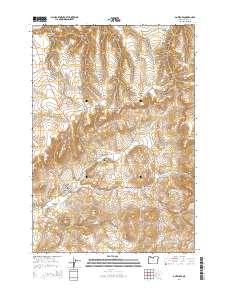
2014 Map of Antelope
USGS Topo · Published 2014About this map
The settlement of Antelope sits at the convergence of several significant geographic drainages in this eastern Wasco County landscape. The town site is nestled within Antelope Valley, where Or-218 meets local thoroughfares like Main St and College St. This 2014 survey documents the rugged canyon country surrounding the community, defined by a network of seasonal watercourses including Antelope Cr, Indian Cr, and Grub Hollow Cr.
Find a feature on this map
27 named features on this map. Tap any name to fly to it.
Don’t see what you’re looking for? This feature index may not catch every label — zoom into the map to look around manually.
Map Details
Editions of this 2014 Antelope Map
This is the sole edition of this map. No revisions or reprints were ever made.
Other maps of this area

1953 · The Dalles
USGS Topo · 1:250,000

1955 · Bend
USGS Topo · 1:250,000

1956 · The Dalles
USGS Topo · 1:250,000

1957 · Bend
USGS Topo · 1:250,000

1957 · The Dalles
USGS Topo · 1:250,000

1958 · Bend
USGS Topo · 1:250,000

1966 · Antelope
USGS Topo · 1:62,500

1966 · Willowdale
USGS Topo · 1:62,500

1970 · Macken Canyon
USGS Topo · 1:24,000
1971 · Bath Canyon
USGS Topo · 1:24,000