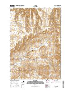
2017 Map of Antelope
USGS Topo · Published 2017About this map
Antelope serves as the primary hub in this arid landscape of north-central Oregon, situated at the floor of the Antelope Valley. The town's grid is defined by streets like Union St and College St, with the local Antelope Cem located just to the north. The surrounding terrain is a complex network of drainage systems and high ridges, including Fraser Canyon, Johns Canyon, and Chapman Hollow. Many of these canyons feed into seasonal watercourses such as Antelope Cr and Grub Hollow Cr. The infrastructure reflects the remote nature of Wasco County, with roads like Bennett Rd and Tub Springs Rd providing access across the varied elevations. The map reveals the relationship between the small settlement and the deeply carved canyons like Wallace Canyon and May Canyon that characterize this portion of the Columbia Plateau.
Find a feature on this map
24 named features on this map. Tap any name to fly to it.
Don’t see what you’re looking for? This feature index may not catch every label — zoom into the map to look around manually.
Map Details
Editions of this 2017 Antelope Map
This is the sole edition of this map. No revisions or reprints were ever made.
Other maps of this area

1953 · The Dalles
USGS Topo · 1:250,000

1955 · Bend
USGS Topo · 1:250,000

1956 · The Dalles
USGS Topo · 1:250,000

1957 · Bend
USGS Topo · 1:250,000

1957 · The Dalles
USGS Topo · 1:250,000

1958 · Bend
USGS Topo · 1:250,000

1966 · Antelope
USGS Topo · 1:62,500

1966 · Willowdale
USGS Topo · 1:62,500

1970 · Macken Canyon
USGS Topo · 1:24,000
1971 · Bath Canyon
USGS Topo · 1:24,000