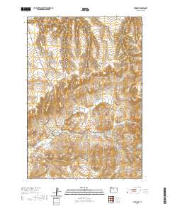
2020 Map of Antelope
USGS Topo · Published 2020About this map
Antelope sits at the heart of this Central Oregon landscape, where the town street grid including Willard St and College St meets the open expanse of Antelope Valley. The town's historical geography is deeply tied to the surrounding drainage systems, with Antelope Cr and Grub Hollow Cr carving through the plateau. To the northwest, the settlement of Shaniko marks a high point in the terrain, connected by local routes that navigate a complex system of draws and canyons such as Johns Canyon and Fraser Canyon. Genealogists and local historians can pinpoint the location of the Antelope Cem situated north of the main settlement. The map illustrates a high-desert environment defined by its water-carved features, including Big Pine Hollow and Laughlin Hollow, which have long dictated the placement of roads and homesteads in Wasco County.
Find a feature on this map
26 named features on this map. Tap any name to fly to it.
Don’t see what you’re looking for? This feature index may not catch every label — zoom into the map to look around manually.
Map Details
Editions of this 2020 Antelope Map
This is the sole edition of this map. No revisions or reprints were ever made.
Other maps of this area

1953 · The Dalles
USGS Topo · 1:250,000

1955 · Bend
USGS Topo · 1:250,000

1956 · The Dalles
USGS Topo · 1:250,000

1957 · Bend
USGS Topo · 1:250,000

1957 · The Dalles
USGS Topo · 1:250,000

1958 · Bend
USGS Topo · 1:250,000

1966 · Antelope
USGS Topo · 1:62,500

1966 · Willowdale
USGS Topo · 1:62,500

1970 · Macken Canyon
USGS Topo · 1:24,000
1971 · Bath Canyon
USGS Topo · 1:24,000