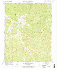
1969 Map of Anthonies Mill
USGS Topo · Published 1976About this map
The eponymous settlement of Anthonies Mill serves as a focal point for this 1969 survey of the Crawford and Washington county line. Situated near the confluence of Brazil Creek and Harris Branch, the community is surrounded by a rugged landscape that transition from active industrial sites to the protected lands of the Clark National Forest. To the north, the massive Pea Ridge Mine footprint on Pea Ridge highlights the area's heavy iron ore mining history, while the Old Christy Mine sits tucked away to the southwest.
Find a feature on this map
33 named features on this map. Tap any name to fly to it.
Don’t see what you’re looking for? This feature index may not catch every label — zoom into the map to look around manually.
Map Details
Editions of this 1969 Anthonies Mill Map
3 editions found
Other maps of this area

1901 · De Soto
USGS Topo · 1:125,000

1903 · Sullivan
USGS Topo · 1:125,000

1906 · Potosi
USGS Topo · 1:62,500

1934 · Meramec State Park
USGS Topo · 1:24,000

1937 · Meramec State Park
USGS Topo · 1:24,000

1943 · Berryman
USGS Topo · 1:62,500

1945 · Berryman
USGS Topo · 1:62,500

1946 · Richwoods
USGS Topo · 1:62,500

1947 · Sullivan
USGS Topo · 1:62,500

1948 · Richwoods
USGS Topo · 1:62,500