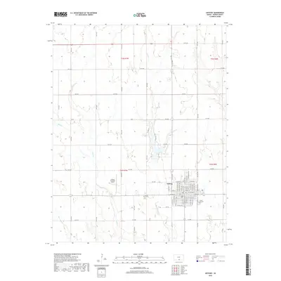
2018 Map of Anthony
USGS Topo · Published 2018About this map
Anthony serves as the focal point of this Harper County landscape, situated at the confluence of a structured street grid and the winding paths of Spring Cr and Rush Cr. The town's layout is defined by its core thoroughfares, including W Main St and E Main St, which intersect with north-south routes like N Anthony Ave and N Jennings Ave. Cultural and community sites are well-documented, from the Anthony Municipal Airport on the western edge to the Forest Park Cem and Spring Grove Cem located near the town's perimeter. Beyond the developed center, the terrain is characterized by a network of rural section roads, such as NW 50 Rd and NE 70 Ave, which delineate the agricultural reaches. Several small waterways, including Bluff Cr and Beaver Cr, weave through the countryside, illustrating the natural drainage patterns that have shaped land use in this southern Kansas region.
Find a feature on this map
73 named features on this map. Tap any name to fly to it.
Don’t see what you’re looking for? This feature index may not catch every label — zoom into the map to look around manually.
Map Details
Editions of this 2018 Anthony Map
This is the sole edition of this map. No revisions or reprints were ever made.
Other maps of this area

1889 · Anthony
USGS Topo · 1:125,000

1889 · Caldwell
USGS Topo · 1:125,000

1891 · Anthony
USGS Topo · 1:125,000

1893 · Caldwell
USGS Topo · 1:125,000

1897 · Caldwell
USGS Topo · 1:125,000

1955 · Wichita
USGS Topo · 1:250,000

1955 · Pratt
USGS Topo · 1:250,000

1958 · Wichita
USGS Topo · 1:250,000

1959 · Pratt
USGS Topo · 1:250,000
1971 · Bluff City West
USGS Topo · 1:24,000