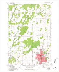
1973 Map of Antigo
USGS Topo · Published 1981About this map
The city of Antigo serves as the focal point of this Northwoods Wisconsin landscape, where the Chicago and North Western rail line bisects the urban grid. The map records a transition from the dense street plan of the city, complete with its Courthouse, to the surrounding agricultural townships of Peck, Neva, and Ackley. Water systems dominate the rural areas, particularly the West Branch Eau Claire River and East Branch Eau Claire River, which converge south of the city. Notable cultural landmarks include several parochial institutions like St Hyacinths Sch and public spaces such as the Fairground. To the north, smaller hubs like Deerbrook and Neva Corners anchor a patchwork of woodlots and farms, while the southern edge of the city features the developing campus of the North Central Technical Institute.
Find a feature on this map
49 named features on this map. Tap any name to fly to it.
Don’t see what you’re looking for? This feature index may not catch every label — zoom into the map to look around manually.
Map Details
Editions of this 1973 Antigo Map
2 editions found
Other maps of this area

1899 · Wausau
USGS Topo · 1:125,000

1902 · Wausau
USGS Topo · 1:125,000

1940 · Parrish
USGS Topo · 1:48,000

1942 · Elcho
USGS Topo · 1:48,000

1950 · Elcho
USGS Topo · 1:48,000

1950 · Parrish
USGS Topo · 1:48,000

1951 · Doering
USGS Topo · 1:48,000

1952 · Parrish
USGS Topo · 1:48,000

1952 · Antigo
USGS Topo · 1:48,000

1954 · Iron Mountain
USGS Topo · 1:250,000