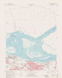
1978 Map of Antioch North
USGS Topo · Published 1978About this map
The confluence of the Sacramento and San Joaquin Rivers dominates this late-1970s landscape, illustrating the complex intersection of industrial growth and conservation in the Delta. In Pittsburg and Antioch, a dense network of residential streets and industrial facilities, including steel mills and waste ponds, borders the New York Slough. Education and community infrastructure are well-established, represented by institutions like Los Medanos College and schools such as Alhambra Sch.
Find a feature on this map
83 named features on this map. Tap any name to fly to it.
Don’t see what you’re looking for? This feature index may not catch every label — zoom into the map to look around manually.
Map Details
Editions of this 1978 Antioch North Map
4 editions found
Other maps of this area

1896 · Mt. Diablo
USGS Topo · 1:62,500

1898 · Mt. Diablo
USGS Topo · 1:62,500

1907 · Antioch
USGS Topo · 1:62,500

1908 · Antioch
USGS Topo · 1:62,500

1910 · Rio Vista
USGS Topo · 1:31,680

1910 · Jersey
USGS Topo · 1:31,680

1914 · Brentwood
USGS Topo · 1:31,680

1916 · Lone Tree Valley
USGS Topo · 1:31,680

1916 · Byron
USGS Topo · 1:62,500

1918 · Honker Bay
USGS Topo · 1:31,680