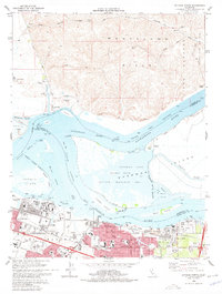
1978 Map of Antioch North
USGS Topo · Published 1978About this map
Industrial expansion and river commerce define this 1978 look at the Sacramento-San Joaquin Delta, where the Pittsburg and Antioch waterfronts meet the marshy islands of Suisun Bay. The landscape is a study in contrasts: the rolling Montezuma Hills to the north overlook a complex network of waterways, including the Deep Water Ship Channel and Broad Slough. Heavy industry is evident in the sprawling Steel Mill and various industrial waste ponds near Los Medanos, while the vast Sherman Island Waterfowl Management Area preserves the ecological character of the wetlands. Transportation hubs are well-defined, showing the paths of the Southern Pacific and Atchison Topeka and Santa Fe RR as they service the growing residential and educational centers like Los Medanos College and the various schools in the city of Antioch.
Find a feature on this map
70 named features on this map. Tap any name to fly to it.
Don’t see what you’re looking for? This feature index may not catch every label — zoom into the map to look around manually.
Map Details
Editions of this 1978 Antioch North Map
4 editions found
Other maps of this area

1896 · Mt. Diablo
USGS Topo · 1:62,500

1898 · Mt. Diablo
USGS Topo · 1:62,500

1907 · Antioch
USGS Topo · 1:62,500

1908 · Antioch
USGS Topo · 1:62,500

1910 · Rio Vista
USGS Topo · 1:31,680

1910 · Jersey
USGS Topo · 1:31,680

1914 · Brentwood
USGS Topo · 1:31,680

1916 · Lone Tree Valley
USGS Topo · 1:31,680

1916 · Byron
USGS Topo · 1:62,500

1918 · Honker Bay
USGS Topo · 1:31,680