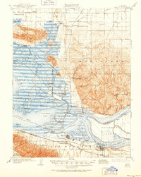
1908 Map of Antioch
USGS Topo · Published 1951About this map
The Sacramento River and San Joaquin River converge in a labyrinth of islands and sloughs, defining the industrial and maritime character of the region. This 1906–1907 survey captures a transitional landscape where established river landings like Meins Landing, Palmetto Landing, and Montezuma Landing served the agricultural interior of the Montezuma Hills. The southern shore reveals the growing industrial hubs of Antioch and Pittsburg, the latter appearing before its full expansion, linked by the Southern Pacific and Atchison Topeka and Santa Fe railroads. Between the tidal marshes of Grizzly Island and the elevated Potrero Hills, the map documents numerous rural landmarks such as Scandia School and Red School, alongside the rail siding at Rio Vista Jct, illustrating the heavy reliance on both deep-water transport and emerging rail lines.
Find a feature on this map
92 named features on this map. Tap any name to fly to it.
Don’t see what you’re looking for? This feature index may not catch every label — zoom into the map to look around manually.
Map Details
Editions of this 1908 Antioch Map
5 editions found

Other maps of this area

1896 · Carquinez Strait
USGS Topo · 1:62,500

1896 · Mt. Diablo
USGS Topo · 1:62,500

1897 · Concord
USGS Topo · 1:62,500

1898 · Karquines
USGS Topo · 1:62,500

1898 · Mt. Diablo
USGS Topo · 1:62,500

1901 · Karquines
USGS Topo · 1:62,500

1902 · Napa
USGS Topo · 1:125,000

1907 · Antioch
USGS Topo · 1:62,500

1908 · Vacaville
USGS Topo · 1:62,500

1908 · Courtland
USGS Topo · 1:62,500