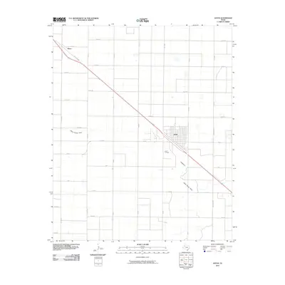
2010 Map of Anton
USGS Topo · Published 2010About this map
Anton serves as the focal point of this South Plains landscape, where the town's grid is intersected by the diagonal path of State Loop 385. The geography is defined by a rigid section-line road network with names like Onion Shed Rd, Maine Rd, and Fisher Rd, reflecting the region's agricultural layout. A subtle natural break in the geometric precision occurs at Yellow House Draw, which meanders through the southern portion of the quadrangle. Outside the main town site, the settlement of Bainer sits to the northwest, while the Anton Cemetery remains a significant landmark for local family historians. The map records a classic Texas panhandle transport pattern, with farm-to-market roads like FM 597 and FM 168 facilitating the movement of goods across the flat, productive terrain.
Find a feature on this map
29 named features on this map. Tap any name to fly to it.
Don’t see what you’re looking for? This feature index may not catch every label — zoom into the map to look around manually.
Map Details
Editions of this 2010 Anton Map
This is the sole edition of this map. No revisions or reprints were ever made.
Other maps of this area

1954 · Brownfield
USGS Topo · 1:250,000

1957 · Anton
USGS Topo · 1:62,500

1957 · Wolfforth
USGS Topo · 1:62,500

1958 · Brownfield
USGS Topo · 1:250,000

1962 · Brownfield
USGS Topo · 1:250,000

1964 · Littlefield
USGS Topo · 1:24,000

1964 · Lums Chapel
USGS Topo · 1:24,000

1964 · Whitharral
USGS Topo · 1:24,000
1976 · Anton SW
USGS Topo · 1:24,000
1976 · Wolfforth NW
USGS Topo · 1:24,000