
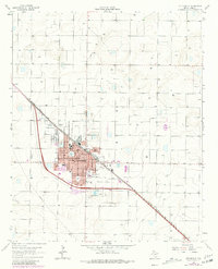
1964 Map of Littlefield
USGS Topo · Published 1966About this map
The urban footprint of Littlefield centers around the active corridor of the Atchison Topeka and Santa Fe railroad, illustrating the town's evolution as a High Plains hub. This mid-1960s survey reveals a community balancing its municipal infrastructure with social and industrial growth. To the north, an extensive Oil Field signals the region's resource-driven economy, while local landmarks like the Littlefield Country Club and a Drive-in Theater reflect the era's recreational lifestyle. The map documents essential community institutions for genealogists, including Emmanuel Ch and the Littlefield Cem, alongside public spaces like Dunbar Park and the Fairground. From the industrial Sewage Disposal sites to the local High Sch, the sheet provides a comprehensive record of the town's physical and social organization before later 20th-century expansions changed the landscape.
Find a feature on this map
20 named features on this map. Tap any name to fly to it.
Don’t see what you’re looking for? This feature index may not catch every label — zoom into the map to look around manually.
Map Details
Editions of this 1964 Littlefield Map
2 editions found
Other maps of this area

1954 · Clovis
USGS Topo · 1:250,000

1954 · Brownfield
USGS Topo · 1:250,000

1957 · Anton
USGS Topo · 1:62,500

1958 · Brownfield
USGS Topo · 1:250,000

1958 · Clovis
USGS Topo · 1:250,000

1962 · Brownfield
USGS Topo · 1:250,000

1962 · Amherst
USGS Topo · 1:24,000

1962 · Cofferville
USGS Topo · 1:24,000

1962 · Fieldton
USGS Topo · 1:24,000

1964 · Oklahoma Flat
USGS Topo · 1:24,000